


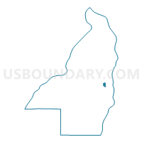
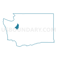
Azalea Voting District, Kitsap County, Washington
About
Outline

Summary
| Unique Area Identifier | 687265 |
| Name | Azalea Voting District |
| County | Kitsap County |
| State | Washington |
| Area (square miles) | 0.56 |
| Land Area (square miles) | 0.48 |
| Water Area (square miles) | 0.08 |
| % of Land Area | 85.69 |
| % of Water Area | 14.31 |
| Latitude of the Internal Point | 47.62947710 |
| Longtitude of the Internal Point | -122.50939270 |
Maps

Graphs
Select a template below for downloading or customizing gragh for Azalea Voting District, Kitsap County, Washington


Neighbors
Neighoring Voting District (by Name) Neighboring Voting District on the Map
- Blue Heron Voting District, Kitsap County, WA
- Ferncliff Voting District, Kitsap County, WA
- Liberty Voting District, Kitsap County, WA
- Wing Point Voting District, Kitsap County, WA
- Winslow Voting District, Kitsap County, WA